FAO GeoNetwork for data access
Purpose of the tool
Geographic maps are effective communicational tools to support decision making, to promote multidisciplinary approaches to sustainable development, and to enhance the understanding of geographic information. FAO GeoNetwork's purpose is to improve access to and integrated use of spatial data and information. GeoNetwork allows to easily share spatial data among different organizations and users.
Target group
- Decision Makers: e.g. Sustainable development planners and humanitarian and emergency managers in need of quick, user-friendly, reliable and up to date cartographic products as a basis for action and better planing and monitoring of their activities
- GIS Experts in need of exchanging consistent and updated geographical data
- Spatial Analysts in need of multidisciplinary data to perform preliminary geographical analysis and reliable forecasts to better set up appropriate interventions in vulnerable areas
Tool description
FAO GeoNetwork provides access to readily available interactive maps, satellite imagery and related spatial databases maintained by FAO and its partners (important partners are WFP, UNEP, and OCHA). At present the project is widely used as the basis of Spatial Data Infrastructures around the world. The project is part of the Open Source Geospatial Foundation (OSGeo) and can be found at GeoNetwork opensource.
FAO GeoNetwork allows to easily share spatial data, including those derived from satellite imagery, among different organizations and users. By combining various layers of information decision makers and planners are able to make better informed decisions for sustainable development of land and water systems.
The following categories are used to group the datasets:
- administrative and political boundaries
- agriculture and livestock
- applied ecology
- biological and ecological resources
- climate and agroclimatology
- fisheries
- forestry
- hydrology and water resources
- land cover and land use
- population and socio-economic indicators
- soils and soil resources
- topography
Result description
Below a readily available map is presented
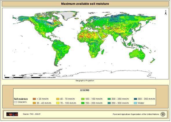
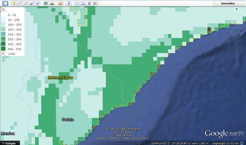
The datasets behind these available maps can be downloaded and opened in Google Earth, for example, see below a detail of the global dataset on maximum available soil moisture.
The tool in practice
GeoNetwork provides mature technology. It is used by FAO and its partners in problem analysis, planning, decision support, and implementation.
Necessary inputs and conditions
Datasets behind the maps can be downloaded and viewed and analyzed in Google Earth which all can be downloaded free of charge.
Contact data
- website
- For information, please contact: GeoNetwork(at)fao.org
Phase and tool category: Problem Analysis & Monitoring and Evaluation
Spatial scale and time scale
Maps are provided at the global scale, but can be zoomed into the local scale (depending on the grid scale of the data set). Datasets and maps can be instantly downloaded, viewed, and analyzed.
Tool availability
LAFAO GeoNetwork maps and datasets are open source available online.
Downloads