Climate App for urban adaptation
Purpose of the tool
The Climate Adaption App gives stakeholders insight in the suitability of adaptation measures in urban development projects. The app is developed to identify and rank feasible climate adaption measures within a minute, so that users can select measures and check their performance on water, drought and heat resilience.
Target group
Urban designers, engineers and other stakeholders in urban development projects - The app has proved to be successful in workshops and training settings.
Tool description
The app, which is available on tablet (high-end smartphone) and PC, includes 120 concrete climate adaptation measures. Users can filter these measures by choosing criteria on climate adaption target and local conditions like soil type, land use, landscape conditions and user preferences. The app then ranks the 120 measures on their total score, based on the selected criteria. This information can be used as information and inspiration in a new development, redevelopment or renovation project. Because of the simple and fast results, it is possible to apply the app in workshops and training settings to explore different climate change adaptation measures.
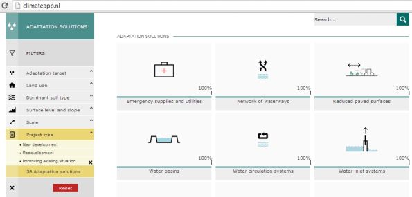
Result description
Earlier sessions have proved the app to be successful in creating inspiration and thinking about different climate adaption measures to find solutions together. For example: If one, on www.climateapp.org, chooses filters on 'drought', 'rural area', 'clay', 'flat area on high ground', 'city' and 'improving existing situation', the app will give the results as illustrated below. The app ranks the measures and proposes the most efficient ones, such as 'network of waterways' and 'water basins'.
The tool in practice
The app has been used and tested in workshops with the municipalities of Delft and Rotterdam, the province of Utrecht and in Ho Chi Minh City and Hanoi. In addition, feedback from Copenhagen and New Orleans has been used in the developement. Although the app can be used in cities around the world, climate information on three pilot cities is included: Rotterdam, Ho Chi Minh City and New Orleans. Conclusions from the tests are that the app is a useful tool to provide its users with inspiration and information by exploring different solutions.
Planned future development of the app focuses on retrieving local conditions from globally available datasets and further tailoring the app for different cities based on detailed local conditions.
Necessary inputs and conditions
A PC with internet connection or an iPad or android tablet is needed.
Contact data
Institutes: Grontmij, Witteveen+Bos, Deltares, KNMI and Bosch Slabbers Landscape + Urban Design
Email: info(at)climateapp.org
Tool website: www.climateapp.nl
Phase and tool category: Strategy development and Planning | Integral approaches
Spatial scale and time scale
Spatial scale ranges from house and street scale to city scale with some links to the basin scale.
Tool availability
The app offers all functionality described above and additional descriptions of the measures, images and photos on the 120 measures. The app can be used at www.climateapp.org and it is available in the Apple Appstore and the Google Playstore