3Di
Purpose of the tool
With 3Di, urban developers, spatial planners, public works specialists and calamity organizations, can easily and precisely calculate and visualize flood risks. Although 3Di is not intended to replace modelling packages for designing and testing water and wastewater systems, it is ideal for exploring measures for improvement.
Target group
The high level of detail, the fast calculation times and the interactive access via a web browser make the area models suitable for a broad target group, varying from water specialists, spatial planners, operational managers and communications advisers through to disaster coordinators.
Tool description
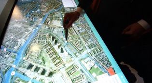
3Di is a dynamic water model, which comprises a number of innovative, interrelated developments, such as new elevation data. These allow the model to make fast and accurate calculations interactively in the cloud and to visualise the results on a touch table, as well as using 3D stereo visualisation. Area models can map out water flows and the effects of flooding, heavy precipitation and drought, both for the current situation and for climatological scenarios.
User can workplay interactively with 3Di, which makes the tool perfect in sessions with stakeholders. Effects of possible interventions can be calculated and visualized, providing maximum support for the evaluations. Policy makers can try out different measures and the software will give them feedback. Additionally, the advanced GIS environment gives specialists the capability to make much larger numbers of changes behind the scenes.
The models can be used for several water and flood risk related applications, such as disaster management, classification of embankments, river management, tackling water problems, urban planning and optimizing the urban drainage system.
Result description
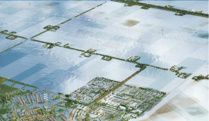
So far, a 3D stereo visualisation of floods is achieved, of which examples are illustrated below. The simulation visualises the course of the flood, swirling through the streets. Furthermore, the interactive modelling has proven to be successful. Users can, for example, raise the dikes during sessions and directly see the results on the course of the flood.
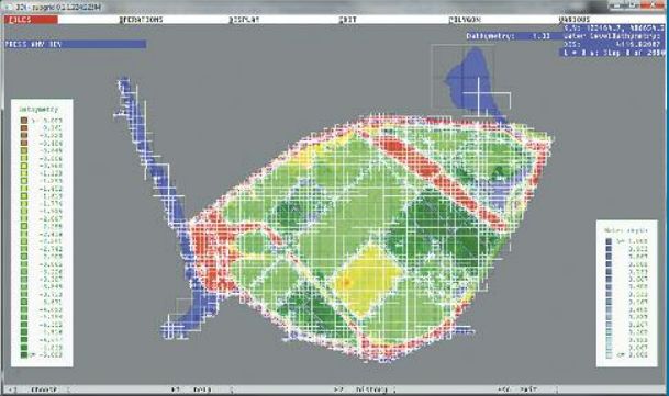
Example of Calculating a flood in a polder in Watergraafsmeer
Visualisation of an historic inundation of the polder Wieringermeer during the second world war (1945).
The 3Di model was calibrated on the basis of written eyewitness information. With a space mouse
the user can 'fly' over the inundated area and zoom in on a specific area.
The tool in practice
The 3Di model has successfully been used at different locations with different applications. The classification of embankments has saved the Hollands Noorderwaterkwartier water authority over hundred million euros. The application on rivers and estuaries was used abroad to make 2D models of Jamaica Bay in New York and San Francisco Bay. The calculation time for these models is just a few minutes, although the models contains a billion cells.
A 3Di case study, related to tackling water problems, carried out in Delfland showed that the water burden in a vulnerable polder could be reduced by eighty per cent. And for Amsterdam, for instance, a 3Di area model has been made down to the level of paving stones. This area model has allowed the vulnerable areas in the city to be mapped out accurately, which is helpful in urban planning.
 |
 |
Necessary inputs and conditions
The user provides information about the available land and water management options, reservoir options, possible extra links in the river network, available capital for investment, and the flood security strategy that is to be followed. The model for the soil-water-plant-atmosphere simulation uses output data from an external model that has been run in a pre-processing phase. This gives flexibility with respect to the used model concept.
Contact data
Institutes: TU-Delft, Deltares and Nelen & Schuurmans
Contact person:
Tool website (Dutch) and international site (English)
Deltares tool information
Phase and tool category: Problem Analysis | Physical Models
Spatial scale and time scale
<information will follow>
Tool availability
3Di is an open development: the formats and the structure of the input and output files of the calculation form are fully open and accessible. The scientific articles can be found in the 'publications' part of the website. An area model is placed in a cloud, which means that quality and problem-free functioning can be guaranteed. Open GIS models can be used to make changes.
Website: http://www.deltares.nl/en/product/1767530/what-is-3di-water-management