Paraná Delta
The Paraná River is considered the third largest river in the American Continent, after the Mississippi in the United States and the Amazonas in Brazil. It is located in South America and it runs through Brazil, Paraguay and Argentina, where it flows into another river called Río de la Plata. The two initial tributaries of the Paraná are the Paranaiba River and the Grande River, both in Brazil, but the most important tributary is the Paraguay River, located in homonymous country (Zagare 2014).
Through the Paraná Delta and the Rio de la Plata estuary drains to the Atlantic Ocean the second major hydrographic basin of South America (La Plata Basin). From a geologic perspective, the complex system of the delta and the estuary are considered a geologic-hydrologic sedimentary dynamic entity (Rinaldi, Abril, and Clariá 2006) which has a vital relevance not only for the region -a high populated area with more than 22 million inhabitants- but also for the hydrology of South American continent. According to the Intergovernmental Panel on Climate Change, the Rio de la Plata, the Amazon and the Orinoco carry into the Atlantic Ocean more than 30% of the renewable freshwater of the world (Bates et al. 2008).
.jpg)
Paraná Delta
Source: Fundación para la Conservación y el uso sustentable de los Humedales / Wetlands International
The Delta of the Paraná River is one of the largest coastal wetlands systems of Argentina, spreading over 320 km and comprising a vast extension of more than 22.587 km2 (Secretaría de Ambiente y Desarrollo Sustentable de la Nación 2008). The Delta presents a variable width, from 18 Km up to 100 km, and according to landscape parameters and hydrologic regimes, it presents different landscape units distributed in 3 zones: Upper, Middle and Lower Delta. The Paraná Delta is rich in biodiversity and natural resources and faces the pressures of urban growth, unsustainable agricultural practices and the consequences of climate change. It is a natural capital which represents a valuable benefit for the human population due to the ecosystem's goods and services.
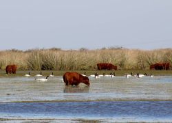
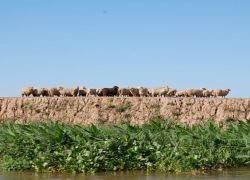
Island cattle raising. Source: Ruben Quintana Sheeps over a dike. Source: Natalia Machain
The Paraná Delta is a complex estuarine model and in contrast to other deltas, it discharge its sediments to the sea through the estuary of the Rio de la Plata (Parker and Marcolini 1992). From the geographic point of view, the Delta was originally restricted to the terrestrial scope, a plain which spreads over three provinces of Argentina (Buenos Aires, Santa Fe and Entre Rios). From a geomorphologic perspective, the Delta is able to be analyzed together with the estuary because of the interaction between the delta plain and its natural limit, the Rio de la Plata (Parker and Marcolini 1992; Cavallotto et al. 2005). Following the distinction of the components of deltas developed by Hori and Saito (2007) it is possible to observe that the subaqueous part of the Paraná Delta overlaps with almost the entire Rio de la Plata’s river-bed. It connotes a relevant influence of the sedimentary processes that form the Delta over the estuary and its coastline. In fact, the Paraná River has a discharge of 18.000 m3/sec and transports around 160 mill ton/year of sediments (28% clay, 56% mud and 16% sand). The sand which is deposited on the river mouth increases the length of the delta, while the mud increments the size producing the emergence of banks that then become islands (Pittau, Sarubbi, and Menéndez 2004). In consequence, the linear advance of the front of the subaerial delta reaches a rate of 50/100 m per year for the sub-front of Paraná de las Palmas, and according to that, it is expected to reach the city of Buenos Aires in 110 years according to Pittau, Sarubbi and Menéndez (2004), which will alter the morphology of the coasts and change the relation between the cities and water (Zagare and van Dijk 2014).
This Delta remains under the dichotomy of the wild condition of its islands and the urbanized growing processes of its edges (Veronica M E Zagare 2014). Along the waterfront of the Paraná Delta exists a network of cities with different scales of importance as well as diverse specializations. From ports to industrial poles or recreation, the cities impact on the delta with different intensity. At a metropolitan level, four urban agglomerations are distinguished along and near the casts of the delta: Buenos Aires Metropolitan Area –the largest conurbation of the country, with a population of around 13 million inhabitants, including the capital of Argentina, the city of Buenos Aies; Gran Rosario Metropolitan Area – the third largest urbanized area in the country, located in the Province of Santa Fe with more than 1.2 million inhabitants; Santa Fe – capital of the homonymous Province, with almost 0.5 million inhabitants; and finally, outside of the Delta but on the coasts of the Rio de la Plata: La Plata city – capital of the Province of Buenos Aires, with a population of 0.7 million inhabitants (Zagare 2014).
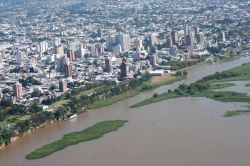
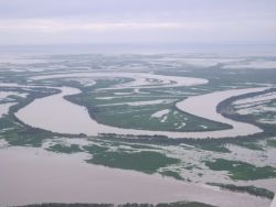
Big cities located around the Delta. Source: Ruben Quintana Aerial view of the Delta. Source: LETyE
The regional importance of the delta is related to its strategic location, along the most important economic corridor of the country, which is also part of the commercial route connecting Santiago de Chile (Chile) and Sao Paulo (Brazil) under the Mercosur economic agreement. The port system that is located along the delta is the most important fluvial network of the country and has always been deeply connected with the terrestrial mobility network of railways and highways. Apart from being the connection with the Atlantic Ocean the system also holds the Paraná-Paraguay waterway or ship channel (Hidrovía Paraná-Paraguay) that links Nueva Palmira port in Uruguay with Caceres Port, located in Brasil (Zagare et al. 2014).
General characteristics
- Continent: South America
- Location (river mouth): 34°16’S, 58°27’O
- Basin of deposition of Paraná River: Rio de la Plata
- Basin of deposition of Rio de la Plata: Atlantic Ocean
- Paraná River length (km): 2570
- Del Plata Basin area (10^3 km2): 3100
- Paraná River Basin area (10^3 km2): 1510
- Delta area (km2): 15000
- Major Cities (Paraná Delta and Rio de la Plata): Buenos Aires, Rosario
- Average rainfall (mm/y) : 1200
- Annual average discharge (m3/s): 18000
- Maximum discharge (m3/s): 50000
- Sediment transportation: 1.600.000 ton/year