Mississippi Delta
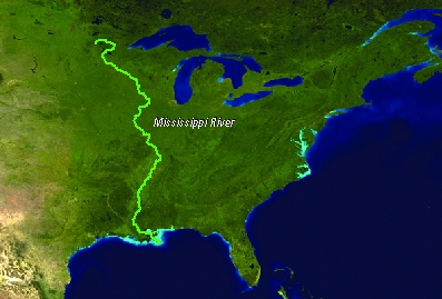
The Mississippi River drains a basin of some 3 million km2, which encompasses a substantial part of the United States of America. The basin extends from the Rocky Mountains in the West, to Canada in the North and the Appalachian Mountains in the East. The discharge of the Mississippi accounts for 90% of the freshwater inflow into the Gulf of Mexico. The Mississippi Delta region comprises much of coastal Louisiana and adjacent Mississippi, and includes the metropolitan area of New Orleans.
 |
The delta complex contains major river channels and levees, numerous bayous, swamps and marshes, lakes, tidal flats and channels, barrier islands, and shallow sea environments. Old abandoned distributary ridges of the river are the only land that is one meter or more above sea level. The land between these ridges are low, flat expanses of wetlands that are highly productive of fish and wildlife. The area of the delta is about 25,000 km2, including 5000 km2 of wetlands and 5,000 km2 of shallow inshore water bodies. |
Water chemistry in the delta grades from fresh to brackish to marine. The Delta is populated by more than a million inhabitants, of which some 500.000 are living in the city of New Orleans. The Mississippi Delta is among the poorest regions of the USA.
Source: Prof. dr. H. de Vriend, Deltares (Delft, January 11, 2009), Towards sustainable development of deltas: Aquaterra research on trends and responses.
Image Source: U.S. Geological Survey
General characteristics
- Continent: North-America
- Location: 28°52’N, 88°14’W
- Basin of deposition: Gulf of Mexico
- Delta area (km2): 28568
- Number of river mouths: 22
- Spring Tide (m): 0.43
- Major Cities: New Orleans
- Basin area (10^3 km2): 3226.3
- River length (km): 6211
- Average rainfall (mm/y): 688
- Maximum rainfall (mm/y): 1532
- Minimum rainfall (mm/y): 169
- Annual average discharge (m3/s): 17704
- Maximum discharge (m3/s): 28161
- Minimum discharge (m3/s): 9579
The Mississippi River Basin and Delta is one of a select few continental-scale source-to-sink systems, the conduit for water, sediment, and solutes delivered to the Gulf of Mexico from a drainage basin of 3.4 x 10⁶ km2, some 41% of the conterminous US. The Mississippi is the 4th largest system in the world in terms of drainage area, and the 7th largest in terms of discharge and sediment load. The alluvial-deltaic region, including related coastal systems and offshore environments, represents rich natural and cultural resources including the infrastructure for 17% of US oil and 25% of US natural gas production and a $3B per year coastal fishing industry, some 30% of the US total. Wetland, estuarine, and nearshore marine habitats are critical to northern Gulf of Mexico coastal ecosystem function, continental-scale carbon and nitrogen cycling and sequestration, and the economy and lifestyles of the people of Louisiana and the US.
The Hurricane Katrina disaster of August 2005 highlighted a problem recognized for decades: the Mississippi River Delta (MRD) is sinking, resulting in extensive loss of wetlands and increasing the exposure of urban and industrial infrastructure to coastal storms (Fischetti 2001; NRC 2005). The problem has been exacerbated by anthropogenic effects including locally accelerated subsidence caused by fluid withdrawal, construction of canals, and reduction of upstream sediment supply due to damming. By far the largest contributing factor to wetlands loss has been the construction of flood control levees along the lower Mississippi River, that has cutting off the river from its surrounding delta plain, thus converting the river into a pipeline that shunts water and sediment to the Gulf of Mexico and starves the wetlands of sediment (Day et al. 2005). The land-loss problem will be exacerbated further with eustatic sea level rise (Blum & Roberts 2009), which is a problem facing deltas and depositional coastlines the world over (Syvitski et al. 2009; Vörösmarty et al. 2009). The urgent need for large- scale wetland restoration through the diversion of Mississippi River water and sediments has been recognized throughout the restoration community (Day et al. 2003; Mitsch & Day 2006; Mitsch et al. 2005, CPRA 2007). This management strategy uses diversion control structures from the Mississippi River to deliver freshwater and sediments to declining wetland areas (e.g., Barataria Bay and Breton Sound) (Day et al. 2005, 2007; Keddy et al. 2007; Kim et al. 2009).
Though land losses are widely distributed across the 300 kilometer (200 mile) wide coastal plain of Louisiana, Atchafalaya Bay stands as a notable exception. In a swampy area south of Morgan City, new land is forming at the mouths of the Wax Lake Outlet and the Atchafalaya River. Wax Lake Outlet is an artificial channel that diverts some of the river’s flow into the bay about 16 kilometers (10 miles) west of where the main river empties. Have a look at this animation of Growing Deltas in Atchafalaya Bay from the Earth Observatory.
There are a variety of programs in research, planning, project implementation, education/outreach, and policy associated with various aspects of restoring the natural and social infrastructure of the Mississippi River Delta. Below is a list of those programs and their web sites, along with other resources and references, to understand the science, engineering, and socioeconomic challenges to sustaining the Mississippi River Delta.
I. University Efforts
A. Coastal Sustainability Consortium: The Coastal Sustainability Consortium is a Memorandum of Understanding (MOU) to create a nexus between university researchers in Louisiana with government agencies and corporate partners to promote effective coastal restoration and protection efforts across coastal Louisiana. This Memorandum of Understanding constitutes a collaborative effort agreement among Louisiana State University and A&M College, Tulane University, University of Louisiana at Lafayette, University of New Orleans for coordinated and joint participation in addressing critical scientific, engineering, social, legal and planning issues in the design and implementation of restoration and protection projects in Louisiana’s coastal area. The science, engineering, and policy disciplines of the four universities comprising this consortium will provide the expertise for developing a sustainable coastal landscape. This MOU establishes the goals and expected benefits the consortium will have, and outlines how this consortium, government agencies and corporate partners will work together to affect coastal restoration. (http://www.coastalsustainability.org/)
B. Coastal Sustainability Studios: The vision of the Coastal Sustainability Studio (CSS) is to use a multi-disciplinary and systems-oriented training framework to develop pragmatic, trans-disciplinary techniques for reducing environmental vulnerability and enhancing community resiliency along the dynamic coast of Louisiana. Deliberately link challenges of storm disturbances, land-use transformations, and climate change to develop adaptation in coupled natural and human systems. The goal of the CSS is to design sustainable systems that reduce vulnerability associated with diverse scenarios of coastal hazards, habitat degradation, and global environmental change. The CSS approach is to promote collaboration of local and out-of-state multidisciplinary experts to find innovative and sustainable solutions to critical problems associated with coastal protection and restoration in Louisiana. The CSS is also a physical location that will be used to incorporate training, learning, and evaluations to help educate and train students, staff, and faculty on the principles and practice of coastal sustainability and systems thinking. The first studio of the CSS is located in Design Building on LSU campus and is managed by staff and executive council. A second studio is being developed at the University of Louisiana at Lafayette.
C. National Center for Earth Surface Dynamics (NCED): he National Center for Earth-surface Dynamics, an NSF Science and Technology Center, is a partnership of research and educational institutions, government agencies, and industry that pursues its goal of predictive Earth-surface science by integrating physical, biological, and social sciences to understand how landscapes and ecosystems evolve together. The goal of NCED's Deltas research program is to develop methods to extract quantitative information on structure and dynamics of depositional systems from stratigraphic records and apply this information to landscape prediction and restoration. (http://www.nced.umn.edu/)
II. NGO Efforts
There are several non-governmental organizations organized to promote the policy, education, outreach and public awareness to encourage stewardship of the Mississippi River Delta from local to state to national agendas.
A. Americas Wetland Foundation: In the largest public awareness initiative in its history, Louisiana is leading America's WETLAND: Campaign to Save Coastal Louisiana. The America's WETLAND Foundation through the Campaign is raising awareness of the impact of Louisiana's wetland loss and increase support for efforts to conserve and save coastal Louisiana. (www.americaswetland.com). The Americas Wetland Foundation organized the World Deltas Dialogue in 2010.
B. CRCL: Coalition to Restore Coastal Louisiana: The Coalition to Restore Coastal Louisiana is a non-profit advocacy organization whose mission is the protection and restoration of a sustainable coastal Louisiana. The goal of the Coalition is to reverse the pattern of net land loss in coastal Louisiana and to reestablish a sustainable balance to its geologic processes and communities. In pursuit of this goal, the Coalition advocates for the implementation of sound coastal policies and monitors coastal activities to ensure that stringent regulations and enforcement policies are maintained. (http://www.crcl.org)
C. Dutch Dialogues: The "Dutch Dialogues" workshops are the outgrowth of extended interactions between Dutch engineers, urban designers, landscape architects, city planners and soils/hydrology experts and, primarily, their Louisiana counterparts. David Waggonner, a local New Orleans architect, initiated this dialogue with Dale Morris, of the Royal Netherlands Embassy in Washington, DC, and the American Planning Association. Waggonner’s and Morris’ efforts on behalf of “Dutch Dialogues” derive from their unwavering belief that New Orleans can survive and prosper and grow only when it gets certain fundamentals in order. Dutch Dialogues exposes and hopefully addresses some of those fundamentals. (http://dutchdialogues.com).
III. Government: There are state and federal
A. Office of Coastal Protection and Restoration: The Office of Coastal Protection and Restoration is responsible for integrating hurricane protection, storm damage reduction, flood control, coastal protection & restoration efforts, and associated infrastructure construction & maintenance in the State of Louisiana. http://www.ocpr.louisiana.gov)
B. Coastal Wetlands Planning, Protection and Restoration Act: The Coastal Wetlands Planning, Protection and Restoration Act, (CWPPRA pronounced kwǐp-rŭh), is federal legislation enacted in 1990 that is designed to identify, prepare, and fund construction of coastal wetlands restoration projects. Since its inception, 144 coastal restoration or protection projects have been built, benefiting over 110,000 acres in Louisiana. The legislation (Public Law 101-646, Title III CWPPRA) was approved by the U.S. Congress and signed into law by former President George H. W. Bush. The annual budget for CWPPRA funded restoration has varied through the nearly twenty year life span of the Act. The budget has ranged between approximately $30 million per year to nearly $80 million per year. The funded Louisiana projects provide for the long-term conservation of wetlands and dependent fish and wildlife populations with cost-effective plans for creating, restoring, protecting, or enhancing coastal wetlands. (http://lacoast.gov/)
C. DRAGON – USGS: The Delta Research and Global Observation Network (DRAGON) partnership is creating an international community of practice to share data on the great deltas and rivers of the world and to develop comparative models and visualization tools in order to facilitate ecological forecasting regarding climate change and development that ultimately helps in guiding decision making. (http://deltas.usgs.gov/)
IV. Presentations (not online available)
-
Day of the Delta Presentation by R. Twilley
-
Delta Dialogue Presentations – R. Twilley
-
CLEAR Overview: publication describing the Coastal Louisiana Ecosystem Assessment and Restoration
-
Overview of the Mississippi River Delta
V. References
- Blum, M. and H. Roberts. 2009. Drowning of the Mississippi Delta due to insufficient sediment supply and global sea-level rise. Nature Geoscience. 2:488-491
- CPRA. 2007. Integrated ecosystem restoration and hurricane protection: Louisiana’s comprehensive master plan for a sustainable coast, Coastal Protection and Restoration Authority of Louisiana (CPRA), Baton Rouge, LA
- Day, J. W., J. Barras, E. Clairain, J. Johnston, D. Justic, G. P. Kemp, J. Y. Ko, R. Lane, W. J. Mitsch, G. Steyer, P. Templet, and A. Yanez-Arancibia. 2005. Implications of global climatic change and energy cost and availability for the restoration of the Mississippi delta. Ecological Engineering. 24:253-265
- Day, J. W., Jr., D. F. Boesch, E. J. Clairain, G. P. Kemp, S. B. Laska, W. J. Mitsch, K. Orth, H. Mashriqui, J. R. Reed, C. C. Watson, J. T. Wells, and D. F. Whigham. 2007. Restoration of the Mississippi Delta: lessons from Hurricanes Katrina and Rita. Science. 315:1679-1684
- Fischetti, M. 2001. Drowning New Orleans, Scientific American. October, 77-85
- Galloway, G., D. Boesch, and R. R. Twilley. 2009. Restoring and protecting coastal Louisiana. Issues in Science and Technology Winter 2009:29-38
- Keddy, P. A., D. Campbell, T. McFalls, G. P. Shaffer, R. Moreau, C. Dranguet, and R. Heleniak. 2007. The wetlands of Lakes Pontchartrain and Maurepas: Past, present and future. Environmental Reviews. 15:43-77.
Kim, W. S., Mohrig, D., Twilley, R. R., Paola, C. and Parker, G. 2009. Is it feasible to build new land in the Mississippi River delta. Eos Trans. AG. 90:373–374 - Mitsch, W. J., and J. W. Day. 2006. Restoration of wetlands in the Mississippi-Ohio-Missouri (MOM) River Basin: Experience and needed research. Ecological Engineering. 26:55-69
- Mitsch, W. J., J. W. Day, L. Zhang, and R. R. Lane. 2005. Nitrate-nitrogen retention in wetlands in the Mississippi River basin. Ecological Engineering. 24:267-278
- Syvitski, J. P. M., and Y. Saito 2007. Morphodynamics of deltas under the influence of humans. Global and Planetary Change. 57:261-282
- Syvitski, J. P. M., A. J. Kettner, M. T. Hannon, E. W. H. Hutton, I. Overeem, G. R. Brakenridge, J. Day, C. Vörösmarty, Y. Saito, L. Giosan, & R. J. Nicholls. 2009. Sinking deltas. Nature Geoscience. 2: 681-689
- Syvitski, J. P. M.. 2008. Deltas at risk. Sustainability Science. 3:23-32
- Twilley, R. R. and V. H. Rivera-Monroy. 2009. Sediment and nutrient tradeoffs in restoring Mississippi River Delta: Restoration vs Eutrophication. Journal of Contemporary Water Research & Education 141:1-6
- Vörösmarty, C. J., J. Syvitski, J. Day, A. de Sherbinin, L. Giosan, and C. Paola. 2009. Battling to save the world's river deltas, Bulletin of the Atomic Scientists. 65:31-43
- Report Mississippi Mission, February 1-2, 2011
