California Bay (Sacramento-San Joaquin)
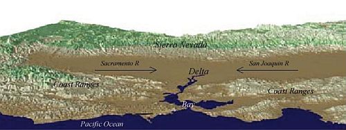
At the heart of California is the six hundred km-long Central Valley. It is a large, relatively flat, fertile area between the coastal mountain ranges and the Sierra Nevada. Its northern half is drained by the Sacramento River and is referred to as the Sacramento Valley, whereas its southern half is drained by the San Joaquin River and is the San Joaquin Valley. The two valleys and their rivers meet between Sacramento and Stockton and form the Sacramento- San Joaquin Delta. A geometrically complex network of interconnected canals, streambeds, sloughs, marshes, and peat islands, which drain into the Suisun and San Francisco Bays and from there to the Pacific Ocean.
The Sacramento-San Joaquin River delta (SSJRD) is an inland delta. The total area of the basin draining to the Delta amounts to nearly 180,000 km2. The Delta, which covers only 2% of the basin, once was a great tidal freshwater marsh covered by peat and peaty alluvium. Beginning in the late 1800s, levees were built along the stream channels, and the land, thus protected from flooding was drained, cleared and planted. Currently the delta has an area of some 4000 km2, of which about 2500 km2 are farmed. Although the area itself is an exceptionally rich agricultural area, its unique value is as a source of fresh water for the rest of the State. It is the heart of the massive north-to-south water delivery system.
Source: Prof. dr. H. de Vriend, Deltares (Delft, January 11, 2009), Towards sustainable development of deltas: Aquaterra research on trends and responses.
General characteristics
- Continent: North-America
- Basin of deposition: Pacific Ocean
- Delta area (km2): 180000
- Major Cities: San Francisco