DELta Analysis and Adaptation Strategy (DELTAAS) viewer
Purpose of the tool
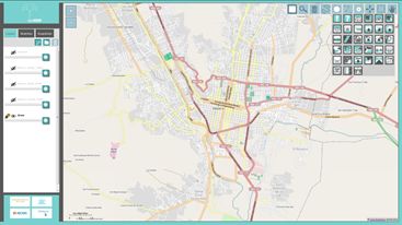
The purpose of the DELTAAS viewer is to support collaborative problem analysis and adaptation strategy development in an interactive setting, for instance during a meeting or workshop. It discloses and visualizes spatial information on the physical, socio-economic and institutional system to a wider audience. The viewer contains maps on impacts and vulnerability and helps stakeholders to identify key adaptation challenges in their areas of interest. Thus, it enables problem analysis, awareness raising, agenda setting, joint fact finding, identification of knowledge gaps, capacity building and the development of joint adaptation strategies.
Target group
The viewer can be used by policy makers, experts and local stakeholders and is particularly useful in multi-stakeholder processes to disclose, visualize and apply information with all groups involved.
Tool description
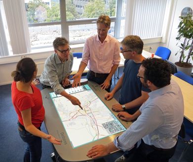
In participatory workshop sessions, participants are firstly familiarized with the touch table through some basic demonstrations and exercises. The purpose of the workshop is explained, and some examples of previous work are shown. Next, the available data is shown, and participants are asked to discuss the data presented and their perception of the situation at hand. Any comments or input by the participants can be recorded immediately on the touch table, and be kept for future reference. By combining different sources of information (e.g. a flood probability map with a map showing occupation patterns or critical infrastructure), expected or potential vulnerabilities can be identified. Subsequently, adaptation measures can be discussed. A series of potential measures are composed beforehand, based for instance on available policy documents and previous studies. Aspects such as appropriateness and effectiveness of the respective measures form part of the discussion and inform the development of an indicative adaptation strategy, for which the different adaptation measures will be allocated to different areas. Subsequently, the indicative adaptation strategy developed can be discussed in more detail, including aspects such as who is responsible for implementation and maintenance of which element etc. Input from the different stakeholders will guide the discussion throughout the workshop in a fully participatory manner. The abovementioned tasks can take place in one single workshop or can be spread out over different sessions.
Result description
MapTable facilitates in the process of getting to mutual agreement among various stakeholders with regard to the various aspects of the design. Within the Building with Nature project, the MapTable concept was made operational for several case studies. For each case a new tool was developed. Understandingly each tool provides different technical results (i.e. coastal interventions, dredging schemes). Results can be used for further study and for verification, for instance with more detailed models.
The tool in practice
The MapTable concept is applicable in a wide range of projects. The concept, as it was developed, aims at projects related to hydrodynamics, morphology and ecology and their interrelations.
The tool has been used in different Dutch projects, such as the 'Stroomlijn project', the 'Room for the River project' and the 'Holland Coast'. Furthermore, it was used as an Interactive Dredge Planning tool in Singapore and at the moment, an application is in development for Bangladesh.
After successful usage in river projects, there is a lot of demand for similar usage for other processes. Deltares is working on applications for broad climate issues, like water quality and flood risks. It will also be possible to illustrate the effects on nature, water quality and ship transport.
Necessary inputs and conditions
The viewer can be used on a large touch screen such as a Touch Table around which participants can stand to work jointly on the problem definition or strategy development. A facilitator is required to guide the collaborative process.
Although more data generally enables a better-founded adaptation strategy, the viewer can also be used in data-poor conditions by making use of open-source data where possible.
Contact data
Institute: Deltares
Contact person: Kymo Slager and Hanne van den Berg
Institute: Alterra, Wageningen UR
Contact person: Jan Dirk Bulens Jandirk.Bulens(at)wur.nl
Tool website
Phase and tool category: Strategy Development and Planning | Physical Models
Spatial scale and time scale
Spatial scale ranging from global through river basin to local;
time scale depends on information and data available
Tool availability
The Delta Analysis and Adaptation Strategy viewer can be used on a variety of hardware options including a Touch Table or other touch screens. It is web-based so it can also be accessed through any regular desktop PC. The viewer is open source.
To receive more information please contact Deltares.