CLUE model for future land use simulation
Purpose of the tool
The CLUE model simulates future land use changes such as deforestation, land degradation, urbanization, and land abandonment. The CLUE model enables a spatially explicit, multi-scale, quantitative description of land cover through the determination and quantification of physical and human drivers of agricultural land use. The maps show where specific land use choices may be successful and how governmental steering policies may work out.
Target group: Governments, NGO’s.
Tool description
The CLUE model is a simulation model to spatially allocate land use changes. The CLUE methodology (Verburg et al. 2002) is based on the analysis of land use dynamics as a multi-level interaction of complex systems. Land use systems operate at the interface of multiple social and ecological systems. The CLUE model is a simulation model to spatially allocate land use changes. The spatial allocation of land cover types is simulated by combining information on the following drivers of land use change:
- relative suitability of a location for different uses
- regional competitiveness of the different land use types
- land use history
- specific land use policies or constraints
The location preference for the different land use types is based on the spatial variation of the location factors that were hypothesized to be important determinants of the land cover pattern. Results of the analysis of drivers are incorporated into a dynamic model, which describes potential changes in the different land cover types in the area over the simulated time horizon.
Result description
CLUE output is given in the form of a time series of land use maps. Changes in land use can be seen from the maps (visually: amount of change, location of change). The amount of change per land use type per spatial area (e.g. country) between time steps can be given as a percentage in relation to the original (e.g. current; 2005) land use map.
Figure: Stacked land use change for Ecuador as an example to show relative changes for all dynamic land uses from 2005 to 2050 (van Eupen et al. 2014)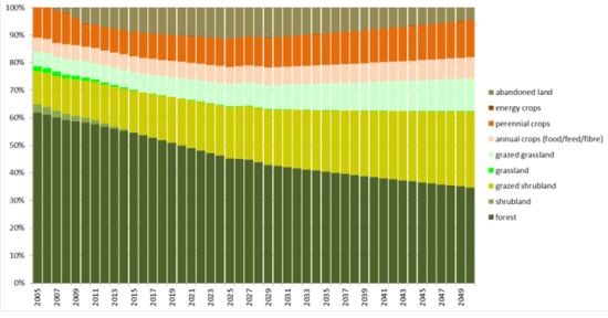
Figure: Original land use (2005) and future land use (2050) under three scenarios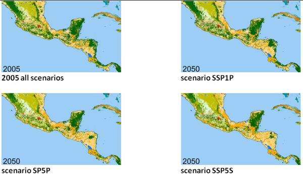
The tool in practice
Applications of the CLUE model have been made around the world in many different environments. Typical applications include the simulation of deforestation, land degradation, urbanization, land abandonment and integrated assessment of land cover change. Specific examples of delta’s applied:
- Mekong Delta
- Rhine Delta, Netherlands: Van Eupen et al 2010
- Pearl River Delta, China Chen et al 2010
Necessary inputs and conditions
The suitability for allocation is calculated as the sum of a number of values (spatial maps) that reflect the determinants of the total suitability. The main determinant of the total suitability is the current location preference in response to the location characteristics such as soil, slope, climate and accessibility of markets. These preferences can be estimated based on expert knowledge or by econometric models. Econometric models can be based on current or historic conditions. It is possible to update this location suitability by scenario specific decision rules that reflect changes in land allocation decisions, e.g. reflecting a more rational or more sustainable land allocation.
Overview of the CLUE model structure: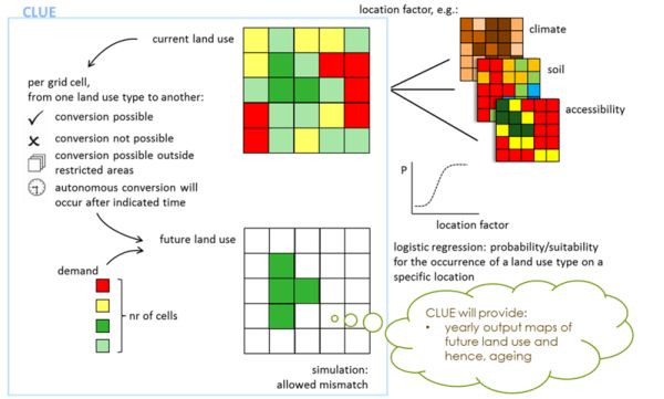
Contact data
Institute: Alterra, Wageningen UR
Michiel van Eupen, E-mail: Michiel.vaneupen(at)wur.nl
Phase and tool category: Problem analysis & Strategy development and Planning | Physical tool
Spatial scale and time scale
The model is applied on all scales: global, through river basin to local scales with time scale varying from 10 – 100 years in the future
Tool availability
Complex tool requiring hired expertise of Alterra. A new version of CLUE was developed in a ongoing current FP7 project (van Eupen et al,. 2014). Demo version of the previous version of CLUE-s is available here.
Download some literature
- Verburg, P.H., Berkel, D.v., Doorn, A.v., Eupen, M.v. and Heiligenberg, H.A.R.M.v., 2010. Trajectories of land use change in Europe: a model-based exploration of rural futures. Landscape Ecology 25(2): 217-232.
- Lin, Y-P., Hong, N-M., Wu, P-J., Wu, C-F., Verburg, P.H. 2007. Impacts of land use change scenarios on hydrology and land use patterns in the Wu-Tu watershed in Northern Taiwan. Landscape and Urban Planning 80: 111-126.
- Hurkmans RTWL, Terink W, Uijlenhoet R, Moors EJ, Troch PA, Verburg PH (2009) Effects of land use changes on streamflow generation in the Rhine basin. Water Resources Research 45, W06405, doi:10.1029/2008WR007574.