Coastal Strategy Development Method
Purpose of the tool
There are many useful solutions to deal with the consequences of sea-level rise. A complex process is needed to choose between all the options. This process comprises a number of important elements, including political support, economic development, sense of urgency, and social implications. The Strategic Development Method (SDM) provides a conceptual framework to help us make these choices thoughtfully.
Target group
Governments and other stakeholders within an specific region confronted with sea level rise.
Tool description
 |
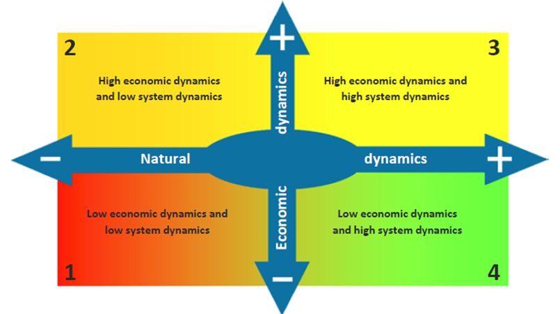
We choose how we deal with the consequences of climate change depending on how we see our common future.
|
Result description
In San Francisco Bay the Strategy Development Method (SDM) has been used to select the appropriate package of measures: the strategy to adapt to sea-level rise. The Scenario Planning Method is used as a basis for building the Strategy Development Method. It shows the different options for dealing with rising tides from different points of view. For this method two key dynamic phenomena have been considered. These interacting dynamic phenomena influence the future of the Bay Area, both sea-level rise and climate change related:
- Economic dynamics
- Low: limited economic importance and development
- High: significant economic activity, which is of great importance
- Natural system dynamics (hydrological and ecological)
- Low: limited natural system dynamics
- High: highly dynamic ecosystem
The tool in practice
The report 'Preparing for the next level', which the SDM is part of, provides new insights on the impacts of climate change on San Francisco Bay, the opportunities this challenge brings and some potential guidelines on how to move forward, as the Bay Area intends to position itself in leading the way nationally and internationally on climate change adaptation. The report is also a landmark in the cooperation between the Netherlands and California, USA on climate change adaptation. A dedicated team of professionals from both countries has worked on this project.
Necessary inputs and conditions
It is a process to go through with stakeholder involvement and meetings; an open process and open minds are necessary inputs.
Contact data
- Arjen Spijkerman (arjen.spijkerman(at)wur.nl, WUR-Alterra)
- David van Raalten (Arcadis, project manager during the project)
Phase and tool category: Strategy Development and Planning | Integral approaches
Spatial scale and time scale
The detail in spatial scale is determined by the river basin modeller when he designs the network schematization and develops the model. This may vary from local to continental, from part of a basin to various basins, from part of an irrigation area to a number of irrigation areas.
The default simulation time steps are day, week, decade, half-month and month.
Tool availability
Assistance required for process facilitation and problem analysis.
Download 'Preparing for the next level', report for San Francisco Bay (4 Mb)