AfroMaison Spatial Data Infrastructure (SDI)
Purpose of the tool
With the Spatial Data Infrastructure (SDI) all kinds of data can be visualized in maps. The tool provides a basis for geospatial data discovery, evaluation, and application for users and providers within all levels of government, commercial and the non-profit sectors, academia and citizens.
Target group: GIS-experts, Policy developers, Planners
Tool description
For Integrated Natural Resource Management (INRM) it is important to cooperate and exchange information. To enhance the management capacity of sub-national authorities and communities, the Afromaison project aims to improve the exchange of information, contribute to filling the gaps and provide a platform for the sharing and geographical expansion of tools for Integrated Natural Resource Management.
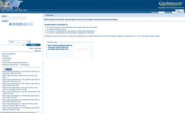
The AfroMaison SDI is built around Free and Open Source Software to make all data and metadata interoperable, discoverable, accessible and integrable using web services. The metadata catalog is based on GeoNetwork, as ilustrated in the last screenshot below, and all data services and webGIS applications are developed around the OpenGeo Community Edition software stack.
The AfroMaison broker is also part of this SDI, allowing users to find even more data coming from heterogeneous sources and all the AfroMaison services have been registered as GEOSS components.
Result description
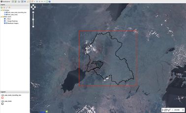
Maps can easily be visualized in a dedicated OpenGeo Suite module called "GeoExplorer" as illustrated below:
AfroMaison geoExplorer displaying webservices
AfroMaison geonetwork metadata catalog
The tool in practice
Five case study sites, covering desserts, highlands, wetlands, grasslands, tropical humid forest and mountain forest, are selected. Each case study has a specific focus as a response to specific pressures, policies and other local conditions.
Necessary inputs and conditions
Inputs for the SDI are provided in the developed data catalogues. For an effective use and further development of the GeoNetwork opensource software, you need to start with familiarizing yourself with the software by going through the point listed at the GeoNetwork developers website. Users and developers can provide feedback and contribute to this site wherever they feel information is lacking, out of sync or is incorrect.
Contact data
This tool has been developed within the Afromaison project framework. It was funded by the European Commission seventh research framework through the AFROMAISON project (Grant agreement no 266379).
Phase and tool category: Agenda setting | Integrated approaches
Spatial scale and time scale
Spatial Scale: Global to local
Time scale: N/A
Tool availability
Free online available via the Afromaison project website.
Download: The tool and catalogue and services are available here.