Rhine-Meuse Delta
The Rhine is one of Europe’s major rivers. From its source in Switzerland it flows through six countries before reaching the North Sea, a distance of 1,320 km. It has a catchment area of ca. 200,000 km2 with more than 58 million inhabitants. The total length of the Dutch coastline is more than 400 kilometres. The coast can be divided into three different parts: the Delta area with tidal inlets in the South (now mostly controlled by open or closed barriers), the uninterrupted Holland coast and the Wadden Sea area (featuring a series of barrier islands) in the North. At present, almost one third of the Netherlands is located below average sea level. Another third has to be protected against flooding by rivers in periods of high discharges.
The use of the river Rhine as an inland waterway has largely contributed to the socio economic development of the Delta. Rotterdam, in the Netherlands, is one of the worlds largest sea ports; Duisburg, in Germany, is the largest inland port in the world. No other river has as many chemical plants on its banks as the Rhine, while at the same time the Rhine water is a source for drinking water for some 20 million people.
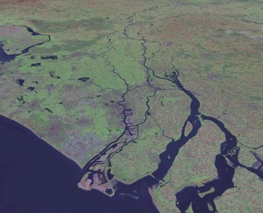 |
The Delta of the Rhine starts at the German – Netherlands border, where the river splits into its two main branches: the Nederrijn and the Waal. Some 10 km downstream, the IJssel branches off in Northern direction. The Nederrijn, further downstream called Lek, continues in Western direction and is connected to the Rotterdam port canal. The southern branch, the Waal, flows in western direction as well. Near Dordrecht it splits in several branches and feeds a large estuary with four interconnected branches. Two smaller rivers, the Meuse and the Scheldt are debouching in the same estuary. |
After a stormsurge caused a devastating flood of 1953, the Dutch started a huge floodprotection programme (Delta plan). Nowadays 4 of the 5 estuary branches, including the Roterdam shipping canal, are protected by storm surge barriers. The area in the estuarine delta that is protected by dikes (the 'land area') is mainly used for agricultural and urban/industrial purposes. It covers approximately 250,000 32 ha. The total area of water and wetlands in the delta is about half of that of the land: 125,000 ha.
Source: Prof. dr. H. de Vriend, Deltares (Delft, January 11, 2009), Towards sustainable development of deltas: Aquaterra research on trends and responses.
General characteristics
- Area and elevation – The Rhine-Meuse delta plain (Pict. 1) measures ~7500 km2. Large parts of the lower delta plain lie below sea level (down to -6 m)
- Discharge of delta rivers – Mean annual discharge of the Rhine is 2300 m3/s; mean annual discharge of the Meuse is 230 m3/s
- Catchment areas of delta rivers – The Rhine catchment measures 185,000 km2; the Meuse catchment measures 36,000 km2
- Geology – Holocene deposits (clay, sand) are up to 15 m thick in the lower delta, where meters-thick peat layers are common
- Flood protection – The delta plain is protected by coastal dunes and an extensive system of dams and dikes. Safety levels are 1/10,000 years for the coastal defense and 1/1250 years for river dikes. Recently river dikes have been strengthened
- Population, major cities and infrastructure – A population of 6,5 million living in the (urban) delta zone between Rotterdam and Amsterdam represents 40% of the population of the Netherlands. The delta plain hosts the four largest cities of the country as well as Europe’s largest seaport and fourth largest airport (Schiphol)
As an initial project of the Delta Alliance network, a comparison of seven of the world’s deltas is being performed. This study compares physical, ecological and socio-economic impacts and adaptive response measures regarding the most affected sectors. Read more.